Last week, the River Ural burst its banks in Russia’s Orenburg Region in what offici 2024-4-19 22:58:14 Author: www.bellingcat.com(查看原文) 阅读量:24 收藏
Last week, the River Ural burst its banks in Russia’s Orenburg Region in what officials have called the worst floods in a century. Russian authorities have evacuated tens of thousands of residents when floodwaters submerged cities such as Orsk, as seen in satellite imagery tasked by Bellingcat.
Climate experts told Reuters the deluge was caused by heavy snowfall followed by a swift rise in temperatures. Bellingcat’s article on Orsk also showed that protection systems could not withstand the deluge, though some locals suggested that improper maintenance was also to blame for the quick collapse.
Kazakhstan’s Central Emergencies Ministry announced on Wednesday that almost 117,000 people have been evacuated across the country. During a visit to the Kostanay Region on Tuesday, Kazakhstan’s President Kasym-Jomart Tokayev described the situation as a national emergency.
The River Ural, which rises in Russia and flows through Orsk into Kazakhstan and the Caspian Sea, is only one of several cross-border rivers which have faced spring flooding. For example, on April 17 the authorities in Russia’s Kurgan Region stated that the Tobol River had risen ‘dangerously’ up to 11 metres in some places. The Tobol is a tributary of the Irtysh, which rises in China and flows through Kazakhstan and Russia into the Arctic Sea.

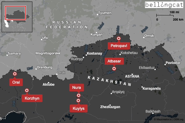
Bellingcat tasked satellite imagery of several locations across northern Kazakhstan in order to better understand the scale of the flooding.
Oral, known as Uralsk in Russian, is the capital of the West Kazakhstan Region. This city of 300,000 lies where the Shagan River meets the River Ural. It is further downstream along the Ural from Orenburg and Orsk, which were badly hit when the river’s water level rose dramatically, as Bellingcat reported last week.
On April 17, local YouTube channel O.Uralsk uploaded drone footage of flooding in the city. While several districts were flooded, the footage indicates that the areas most severely affected appear are those located on floodplains to the south-east of the city itself. These are rows of small houses, or Dachas, close to the River Ural, namely the the 1st, 2nd, and 3rd Dachnaya Districts (roughly 51.199051, 51.454062) and houses in the Kazinsky Dachas area.
This comparison of Planet satellite imagery between April 17, 2023 and April 16, 2024 shows the full extent of the flooding, with several houses in the 1st, 2nd and 3rd Dachnaya districts submerged beneath the brown floodwaters of the widened River Ural.
Further south, at the Kazinsky dachas (51.132945, 51.375352), the flooding was not as dramatic as in other parts of Oral, but many houses appeared partially flooded by the higher water levels. Nearly all the surrounding low-lying land has been inundated by brown floodwater.
The city of Petropavl lies 1,250 kilometres to the west of Oral. With a population of 200,000, it is the capital of the Northern Kazakhstan Province. The city lies about 430 kilometres north of Kazakhstan’s capital of Astana, which also lies on the Ishim River. On April 13 the Kazakhstan service of RFE/RL, Radio Azattyq, reported that earthen flood barriers had been breached and that water was flooding the city.
The comparison slider below shows Planet satellite imagery of Petropavl on April 11, 2024 and on April 17, 2024. Two districts have been entirely inundated. These are the Podgora District (54.880846, 69.107565), the urban area on the eastern bank of a bend in the river, and the Zarechny District (54.901813, 69.118498) on the western bank, slightly to the north.
The slider below shows the Podgora District in more detail, comparing the same Planet satellite imagery.
You can take a closer look at the Zarechny District below, comparing Planet satellite imagery from May 4, 2023 with April 17, 2024.
Even in areas of Petropavl which do not appear fully submerged, the effects of the flooding are still visible. Pay attention to the changing colour of the city’s streets. The diagonal brown line seen at (54.886152, 69.133307) is Pushkin Street in the city centre, submerged in brown floodwater. It is not the only such example, but is among the most visible.
The town of Atbasar in the Akmola Province is further upstream along the River Ishim, about 380 kilometres south of Petropavl.
The slider below compares Planet satellite imagery from April 14, 2024 with November 8, 2023. The River Ishim has burst its banks, flooding dozens of houses.
Water levels in the River Zhabay, a tributary of the Ishim to the north-west of the town, have also risen dramatically.
Atbasar’s Middle School Number Four close to the river can be seen submerged by the floodwaters. This same school (51.813837245, 68.37320646) was among the flooded locations filmed by a local vlogger, who also uploaded his drone footage to YouTube on April 11.
Comparatively less is known about the situation in smaller, remote villages in this vast, sparsely-populated country. The village of Nura in the Aktobe Region (48.896011, 62.307994) is a case in point. This settlement of around 700 people lies in between lakes connected by the River Torgay, which rises and ends inside Kazakhstan.
News website Diapazon reported on April 14 that a protective dam outside the village collapsed under the force of the floodwaters. This could not be verified through available satellite imagery. According to one local resident interviewed by Kazakh media website 24.kz on April 15, the two-storey school is now underwater and people were evacuated by helicopter. According to one Russian news website, 24 residential homes in Nura were underwater by April 17.
The GIF image below compares Planet satellite imagery from October 9, 2023 with images from April 4, 12, 15, 16 and 17. It shows how the floodwaters advanced over nearly two weeks; as the river and lake expand, Nura becomes a peninsula all but entirely cut off from other land.
Seventy-five kilometres away in the same region to the south-west lies the village of Kuylys (48.245236, 62.068342), where the Torgay and Irgiz Rivers meet.
The slider below compares Planet satellite imagery between April 6 and April 12. The water levels in the Torgay River have risen substantially, but the village itself was not entirely flooded.
This may be because of actions taken by residents of the area who, according to Diapazon, created a chat group to organise themselves and proactively request assistance from the authorities. Aryp Koyshybaev, a native of the village, told Diapazon on April 17 that “if residents had not taken things into their own hands, Kuylys would have gone underwater like Nura”.
Diapazon published photos of villagers holding bags of earth, suggesting that they may have constructed earthen barriers to keep out floodwaters as have been seen elsewhere. For example, on April 17 locals from the town of Perovsky in Russia’s Orenburg Region opted to build their own flood defences rather than evacuate.
Less fortunate was the village of Korzhyn in the Western Kazakhstan Region (49.449484, 53.503737), which lies on the River Zhaksybai. This village of 700 people was completely submerged in late March.
Resident Arai Aitlakieva told Radio Azattyk that the flooding started at noon on March 27 and that ‘the village was flooded in literally two to three hours’.
The slider below compares Planet satellite imagery from October 22, 2023 with March 29, 2024.
On March 28, 24.kz reported that over 100 people had been evacuated from Korzhyn by helicopter and that the village’s livestock had died.
Flooding continues across Russia and Kazakhstan, where emergency services are evacuating residents of towns at risk.
Bellingcat is a non-profit and the ability to carry out our work is dependent on the kind support of individual donors. If you would like to support our work, you can do so here. You can also subscribe to our Patreon channel here. Subscribe to our Newsletter and follow us on Instagram here, YouTube here, Facebook here, Twitter here and Mastodon here.
如有侵权请联系:admin#unsafe.sh